Area and Boundaries
Area and Boundaries
The north boundary, towards SR.Yugoslavia, goes west-east, with total length of 231 km. It is mostly a natural boundary, since it goes through high mountaineos parts, and, also, mostly ethnical, since it separates the Serbs to the north and the Macedonians to the south.
This boundary was set in 1945. However, it left the monastery of St. Prohor Pcinjski out of Macedonia's boundaries, although the monstery is of great importance for the macedonian people. There are also some Muslims living in the area known as Gora on Sar Planina, who speak in clear Macedonian tongue. These questions have not been yet considered.
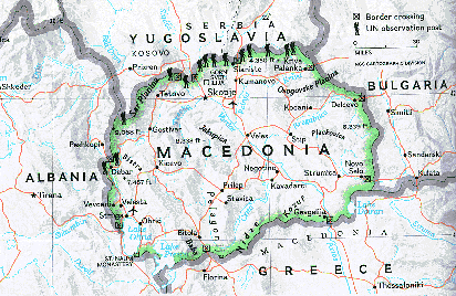
The south boundary, towards Greece, goes east-west, with total length of 262 km. This is the longest of the Macedonian boundaries. It is not a natural boundary, since it goes trough the Dojran and the Prespa lakes and the Pelagonia ravine. It is not an ethnical boundary, since there are a lot of Macedonian living in Aegean Macedonia which now belongs to Greece.
The west boundary, towards Albania, goes south-north, with total area of 191 km. It is mostly natural, since it goes through the highest point of the mountains in western Macedonia, and it is hard to pass. It is unnatural in those parts where it goes through the lake of Ohrid and the lake of Prespa. It is not an ethnical boundary, since there are a lot of Albanians living in Macedonia, as well as a number of Macedonians living in Albania.
Among these boundaries, Republic of Macedonia has a total area of 25,713 sq.km. However, this is just a part of the area of ethnic Macedonia, which had an area of 68,451 sq.km. After the Balkan Wars and the division of Macedonia in 1913, Pirin Macedonia was taken by Bulgaria, Aegean Macedonia was taken by Greece, Vardar Macedonia was taken by Serbia, and some small parts were given to Albania. The territory of today's Republic of Macedonia was actually the part that in 1913 was taken by Serbia, i.e. Vardar Macedonia.